Palestinian Negev
The Negev Desert is located in the southern part of occupied Palestine, and constitutes nearly half of its historical area. It is of great importance to the Israeli occupation state, as it covers about 60% of its area, thus providing a wide space for settling Jewish immigrants and establishing extensive economic development projects, made possible by the Negev’s richness in mineral resources and its possession of agricultural potential.
The occupation established its most important strategic projects in the Negev Desert, most notably the Dimona nuclear reactor, military and security bases, air bases, training centers, military colleges, prisons, and spy stations, the largest in the Middle East.
60% of the Bedouin (the indigenous people of the Negev) are confined to 7 towns and 11 villages, which lack basic infrastructure and services, and whose inhabitants suffer from the destruction of their traditional culture, and high rates of poverty and unemployment, while 40% of them are spread across 35 villages that the Israeli authorities refuse to recognize, and accordingly deprive their inhabitants of their basic rights such as water, electricity, transportation, health and education, and they face a constant threat of eviction or forced displacement and demolitions.
Israeli facilities in the Negev Desert :
The Negev Desert is a vital part of the strategic facilities that have been the backbone of Israel since its occupation of Palestine. These facilities include major strategic projects such as the Dimona nuclear reactor, important military and security bases, prisons, and spy stations that are the largest in the Middle East. These facilities were established since the period of the Israeli occupation of the Palestinian territories in the Negev, and are essential to Israel’s strategy and national security. Here are the most prominent of these facilities:
Dimona nuclear reactor in the Negev desert
Israel has a nuclear reactor known as the Dimona reactor in the Negev desert. The reactor was built in 1958 with French assistance and was completed in 1964. Israel is believed to have between 80 and 90 nuclear warheads made from plutonium produced at the Dimona reactor.
However, Israel has not officially declared its possession of nuclear weapons and maintains a policy of non-disclosure. The Dimona reactor is one of the country’s main military and political secrets, and talking about it is almost forbidden. Recently, extensive construction and expansion work has been reported at the Dimona reactor, the largest of its kind in decades. This activity has been documented by satellite images published by the Israeli media.
The Dimona reactor is eight stories underground, where burned nuclear fuel is processed. The reactor is believed to be used as a first stage in the production of atomic bombs. The reactor has a large capacity to produce about nine kilograms of plutonium per year, which is enough to make a nuclear bomb with a power of up to 20 kilotons of explosives, which is the same explosive power as the atomic bomb that the United States dropped on the Japanese city of Nagasaki during World War II.
Military base in the Negev desert
In March 2014, the Israel Defense website revealed Israeli plans to transform the Negev into the country’s largest military base, which would accommodate tens of thousands of soldiers and include bases for cyber warfare and advanced military technology, in addition to a classification and absorption center for recruits.
Ramon Base in the Negev Desert
Located about 30 kilometers from the Egyptian Sinai Peninsula, Ramon Air Base, known by its Hebrew name “Knav 25,” is the wing that houses the most powerful fighter squadrons in the Israeli Air Force. It serves as a launching pad for Israeli aircraft used to target the Gaza Strip. The base was built in 1982 with American funding, as part of the redeployment of the Israeli Air Force outside the Egyptian Sinai after it was handed over to Egypt under the Camp David Accords in 1978.
Ramon Airport in the Negev Desert
Ramon Airport is located in the Timna Valley in the southern Negev Desert. It was built as an alternative to Eilat Airport and is located about 18 kilometers north of Eilat, near Be’er Ora. The airport has a 3,600-meter runway, allowing large aircraft to land. Ramon Airport opened in January 2019 and is named after Ilan Ramon, a military pilot and Israel’s first astronaut, who died along with his son Asaf in a training accident.
Hatzerim base in the Negev desert
Hatzerim Air Base is located in Beersheba, near the agricultural and military settlement of Hatzerim. The base was established in the early 1960s and became operational in October 1966. The base has housed the Israeli Air Force Museum and the Israeli Air Force Flight Academy since April 1966. The base was built by order of Israeli Air Force Commander Ezer Weizman, designed by architect Yitzhak Mor, and its first commander was Yosef Allon.
Nevatim base in the Negev desert
The Nevatim Air Base is located in the eastern Negev, southeast of the city of Beersheba. The base was established in 1947 under the name “Malhatta” as an airstrip. It was rebuilt with American assistance after the signing of the Camp David Accords between Israel and Egypt. The Nevatim base is of strategic importance as it houses the headquarters of the Israeli Air Force’s Strategic Air Command. The Nevatim base is equipped to receive the American fifth-generation F-35 fighter jets, in addition to the presence of advanced simulators for training pilots inside the base. It is worth noting that the F-16s stationed at the Nevatim base participated in the bombing of the Iraqi nuclear reactor in 1981.
US-Israeli base in the Negev desert
In September 2017, the United States and Israel announced the opening of the first permanent joint US-Israeli missile defense base in the Negev Desert. The base is intended to enhance military cooperation between the two countries and provide joint protection against potential missile attacks on Israel.
Arava Station in the Negev Desert
In the Negev Desert, a solar power plant has been built within the existing Israeli facilities there. In June 2011, the Israeli energy company Arava announced the launch of the first commercial solar power plant in the region. The company confirmed that this plant is the first of a group of about 50 other plants planned to be built in the Negev Desert. These plants aim to generate electricity using solar energy.
Beersheba University in the Negev Desert
Founded in 1965, with the aim of developing the south, the University of Beersheba was initially known as the Negev Institute of Higher Education. In 1969, its name was changed to Ben-Gurion University. The university is an important center for academic education and scientific research, and contributes to many fields including desert agriculture, archaeology, and medical research.
Phosphate mines in the Negev desert
In the area west of Arad in the Negev, an abundance of phosphate, a material used in the manufacture of weapons and agricultural fertilizers, was discovered. In 2018, approval was given to build a phosphate mine in that area, which led to the confiscation of an area estimated at 26,000 dunams.
Location and area
The Negev Desert is located in the southern part of occupied Palestine , bordered by the Araba Valley to the east, the Sinai Peninsula and the Gaza Strip to the west, and the Hebron Mountains and the Hebron Desert to the north. The Negev takes the shape of an inverted triangle, its apex to the south at the Gulf of Aqaba, and its base to the north, extending from Ashkelon in the west to the Dead Sea in the east. It extends east from the southern part of the Dead Sea to the Gulf of Aqaba, and west from Gaza to Taba.
Its area is estimated at more than 12.5 thousand square kilometers, which constitutes approximately half of the area of historical Palestine (27 thousand square kilometers), and about 60% of the area of the Israeli occupation state. The longest distance in the Negev is about 190 kilometers, and its widest is about 80 kilometers.
terrain
The Negev region is an extension of the Sinai Desert, and consists of diverse natural features, including the following terrain:
Climate
The Negev region is located within the desert belt, and its climate is considered to be of the “continental” type, with two prominent characteristics: sharp differences in temperatures between day and night, summer and winter, and dryness due to very limited amounts of rainfall.
The average temperature is more than 20 degrees Celsius, and rainfall rates vary, with the average being less than 200 mm per year, decreasing as we move from the northwestern edge of the region towards the Arabah Valley and the Eilat region to the south, reaching approximately 300 mm in the north, while decreasing to between 50 and 200 mm in the centre and south.
Population
The Palestinian Bedouins and Arab tribes whose origins go back to Canaan and the Arabian Peninsula are the original inhabitants of the Negev, but with the establishment of the Israeli occupation state in 1948, most of them were displaced, and only 11,000 Bedouins remained out of approximately 92,000, on whom the occupation authorities imposed harsh conditions and seized their lands.
The population of the Negev is 770,000, of which 36% are Bedouin, or 300,000 people. 50% of them live in the city of Rahat and 6 urban towns, 10% in 11 recognized villages, distributed among two regional councils, while 40% of them are spread across 35 unrecognized villages. (Regional Council of Unrecognized Villages in the Negev).
The Bedouins occupy only 3.5% of the total area of the Negev, so the population density in those areas is higher than in their counterparts in the Israeli areas, as the population density in the Arab areas is 371.5 people per square kilometer, while in the occupied areas it is 21.4 people per square kilometer.
Economy
Minerals form the main basis for industrial development projects in the Negev, the most important of which are concentrated in the cities of Beersheba, Dimona and Arad.
The Negev Desert is rich in many mineral resources, the most important of which are uranium, phosphate, and natural gas. The Negev lands also contain potash, bromine, and magnesium, which are extracted in Sodom, at the southern end of the Dead Sea. Copper is extracted in Timna, and there are large deposits of clay minerals and glass sand for the ceramic and glass industry.
Although the Negev region is a dry region, it has agricultural potential if irrigation water is available. However, Israel has transferred water to it from the northern regions, through a number of projects. Water is transferred mainly from Lake Tiberias through a number of pipes to the central Negev, which has given the region great economic importance.
The Negev produces good crops of grains, fruits, vegetables, cotton, fodder crops, sugar beets and flowers. The region is also popular for tourism, with many natural wonders, hiking trails and sights.
the date
The Canaanite, Amalekite and Edomite tribes were the first to settle in the Negev Desert, and then moved from a nomadic lifestyle to a settled lifestyle.
Excavations have also revealed human remains in the area dating back to the Late Stone Age (c. 7000 BC), and tools from the Copper and Bronze Ages (c. 4000-1400 BC) have been found on the central Negev Plateau.
Life in the Negev Desert can be traced back to Bedouin tribes that passed through the area more than 4,000 years ago.
Early settlements were heavily influenced by Egypt, which was the first to introduce mining and smelting to the region, and the mining industry in the Negev Desert flourished to become a major economic power coinciding with the rise of the Assyrian Empire in Jordan.
The Negev became a major transit route for traders and others seeking economic gain, and its urban centers were supported by irrigation and winter rain conservation systems, borrowed from the Nabataeans, which also made the Negev a thriving agricultural region.
During that period, the Nabataeans exercised political control over the Negev, and had a prominent position in international trade. They exploited the trade routes that passed through the region to transport spices between the city of Petra and Gaza. With their rule, settlements flourished on the trade route known as the “Incense Route.” The cities of the Negev, such as Abda, Mamshit, and Al-Khalasa, were famous at that time for their important commercial centers.
In 106 AD, the region fell under the control of the Roman Empire, and witnessed a decline in its importance, but despite that, it remained an important source of grains in that era. In the middle of the third century AD, it revived again, during the Byzantine era. In the seventh century, the Islamic conquest entered it, and agricultural development increased, which led to the settlement of the remaining semi-nomadic tribes in the region.
The Negev witnessed its most prosperous eras during the Byzantine and Umayyad eras, when commercial cities developed and agricultural settlements spread over vast areas of the region.
In 1900, the Ottomans established the first city in the Negev, the city of Beersheba. The Ottoman authorities bought about 2,000 dunams from the Azzazmeh clan and built the city on it in an attempt to push the families towards stability.
An administrative center for southern Palestine was established in Beersheba, schools were built, a railway station was established, and the state recognized the authority of the tribal leaders over the region. The cultivated lands in 1920 were estimated at about 3,750,000 dunams.
Negev Bedouins
Bedouins are Palestinian Arabs, and the term “Bedouins” is used to refer to their nomadic lifestyle. They have historically been known for animal husbandry, herding, and agriculture.
The Bedouin population of the Negev in 1947 was over 92,000, and they owned land under a clearly agreed and clear “traditional” system of individual and collective land ownership rights (Minority Rights Group International Indicators).
Most of the lands in the Negev were owned by the Bedouins by inheritance, without any written document. In 1858, the Turks passed a law requiring the official registration of lands in the names of their owners, but the Bedouins of the Negev did not register their lands, due to their unwillingness to be subjects of a foreign country, which entailed paying taxes and serving in the army.
In 1921, the British Mandate government issued an order calling on the residents of the Negev to register their lands, but they did not respond, and they remained unregistered.
With the declaration of the establishment of the occupation state in 1948, most of the Bedouins were displaced from their lands and moved to live in Jordan, Syria, the West Bank and Gaza. As a result, their number in the Negev decreased, and only 11,000 people remained, representing only 19 tribes out of 95 tribes that lived in the region. (Indicators of the International Minority Rights Group).
The remaining Bedouins were treated harshly, and the occupation government seized their lands, forcing them to live in a small area in the Negev, where some Bedouin families already lived, known as “the fence,” which amounted to about 1.5 million dunams, compared to the 13 million dunams where the Bedouins originally lived.
Most Bedouin lands were confiscated under the Land Acquisition Law of 1953, which stipulated that any land not owned by its owners in April 1952 could be registered as state property.
In 1965, the Israeli authorities drew up a plan to develop the Negev, annexing most of the Bedouin lands and considering them state property. Houses or other buildings built on these lands were deemed illegal, and the law stipulated that unlicensed buildings may not be connected to utilities such as water and electricity.
During the 1960s, the government decided to settle the Bedouins, and built planned towns in the Negev. “Tel Sheva” was the first city to be established, in 1969, followed by “Rahat” in 1972. Ten years later, “Kasif” and “Arara” were built, and by 1990 three more towns were built: “Segev Shalom,” “Hura,” and “Laqiya.”
These seven towns are the poorest in Israel, and they lack infrastructure such as health, roads, education, electricity, water, and others. Despite this, the occupation authorities have besieged about 50% of the Negev Bedouins in them.
About 100,000 Negev Bedouins live in 35 villages that the Israeli authorities refuse to recognize (Minority Rights Group International, 2018), and as a result, their residents are denied basic rights such as water, electricity, sanitation, health services, education and transportation. The occupation also sprays agricultural fields to destroy crops, uproots trees and confiscates livestock.
The Bedouins suffer from increasing poverty and unemployment due to the harsh conditions imposed on them, while their traditional culture is being erased and obliterated, and they face the constant threat of eviction or forced displacement by the occupation authorities. Over the years, tens of thousands of them have been displaced and their lands have been seized.
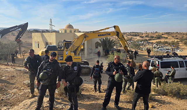
They are also subjected to repeated home demolitions, with the number of homes demolished between 2015 and 2020 reaching approximately 10,000 buildings in Arab towns in the Negev. (Regional Council of Unrecognized Villages in the Negev).
The Israeli government supports the expansion of settlements on Bedouin lands in the Negev. Settlers face no restrictions on how and where they can live. Israeli authorities refrain from developing and expanding the building areas of 11 villages that it recognized more than 16 years ago, which lack infrastructure and basic services. Residents of the “fence” area face the risk of displacement and eviction, through the intensification of Israeli infrastructure projects.
Negev Bedouin tribes
The Negev Bedouins consist of four large Arab tribes, with numerous clans and sub-clans, which owned the Negev Desert and the entire Beersheba District. These tribes are:
Most important cities
The Negev region includes many important cities, some of which have a long history, and some of which are modern cities that were established by the Israeli occupation on the stolen Palestinian lands, to accommodate the numbers of Israeli immigrants coming from all over the world. Industrial cities and urban settlements were established as regional centers for agricultural areas. The most important cities in the Negev are:
Beersheba city
Located 71 kilometers southwest of occupied Jerusalem, it is the largest city in the Negev Desert, and one of the oldest and most important Palestinian cities. It is often referred to as the “Capital of the Negev” because it is one of the most densely populated cities. It is a center for trade and communication between merchants from Jerusalem, Hebron, Gaza, Majdal and Bedouin tribes. Agriculture is active there and it includes many industrial centers.
The inhabitants of Beersheba before the Nakba were a group of Bedouin tribes. After 1948, Israel seized the city and built settlement outposts around it, demolished most of the homes of its Arab inhabitants, displaced most of its original inhabitants, and settled Jewish immigrants in their place.
Dimona city
Located 35 km southeast of Beersheba, it was founded in 1955 to settle Israeli immigrants, most of whom were Eastern Jews from North Africa, who were employed in phosphate and salt factories in the Dead Sea and northern Negev. The Israeli nuclear reactor was built next to the city in the late 1950s and early 1960s, and bears the city’s name. Eilat: An ancient port and tourist resort located at the southern tip of the Negev at the head of the Gulf of Aqaba.
The city was established in 1950 on the lands of the Arab city of Umm Rashrash, and during the sixties and seventies of the twentieth century, hundreds of Jewish families were attracted to live there, and a few Arab families.
The city is located on the road leading to the Arabian Peninsula, known as the (Hajj Road) in reference to the pilgrim caravans from Palestine and Egypt towards the Hijaz. It also has strategic importance, as it has been used throughout the ages as an important military base.
The residents of Eilat depend on the port-related businesses and services associated with the tourist and recreational facilities established there, such as: hotels, swimming pools, fish and coral exhibitions, and the tourist port.
Rahat city
It is located in the northern Negev, and is part of the Beersheba District. It separates the Negev Desert from the rest of the regions in Palestine. It was established in 1972, and before the occupation, the area was owned by the Tiyaha (Hazel) tribe and was called “Hazel.”
It is considered the largest Bedouin center in the Negev Desert, and its people are dominated by tribal traditions and customs. It includes an industrial area, in addition to a large market located in the city center, where many Palestinian vendors work.
Tel Arad City
Located east of Beersheba, it was established as a town in 1962 on the lands of the Palestinian village of Tel Arad and adjacent lands. Its population increased after the immigration of Jews in the 1990s, and it is now inhabited by a wide spectrum of Israeli society: Ashkenazim, Sephardim, secularists, religious, black Hebrews, native-born Israelis, new immigrants, and the indigenous Arab population that remained after the 1948 war.
Israeli settlement
In the late 1930s, the Jewish National Fund expanded the scattered properties in the Negev that had previously been acquired by individual Jews, and thus three kibbutzim (collective settlements) were established in 1943: Gevolot, Beit Eshel, and Revivim.
After the end of World War II, 11 more settlements were established by 1946, and 4 settlements by 1947. All settlements were supplied with water, via two pipelines, bringing water from the southern coastal plain.
After the establishment of the occupying state in 1948, the importance of developing this large part of the country was realized, and in accordance with the National Water Plan, pipelines and canals began to transport water from northern and central Israel to the Negev regions. In the armistice agreements with Egypt and Jordan in 1949, Israel’s control over the entire Negev was approved, with the exception of the Gaza Strip.
During the 1990s, the region absorbed a large number of immigrants from the former Soviet Union, a process that led mainly to the increase in urban settlements in the Negev. Interest in the region increased over the following years, and many settlements and urban areas were established and their infrastructure developed, and the state encouraged Jews to settle there.
In 2005, the Israeli government approved the so-called “National Strategic Plan for the Development of the Negev,” which aims to increase the number of Jews to nearly one million by 2015, while the number of Arabs does not exceed 200,000. It allocated 17 billion shekels to implement the plan (more than 4 billion dollars).
In November 2010, the Israeli government allocated a budget of $25 million to begin implementing the “Wine Route” plan, which calls for the establishment of individual farms for Jews on Arab lands in the Negev. The plan stipulates the establishment of 100 new farms, in addition to 41 individual farms that Jews had established illegally, and the allocation of an area of 80 dunams free of charge to every Jewish family that agrees to settle.
In 2013, the occupation authorities passed the “Begin-Prawer Law” as part of a plan to militarize the Negev Desert, Judaize it through settlements, and eliminate the Palestinian presence. The law requires the seizure and confiscation of 850,000 dunams of Palestinian Bedouin land, the demolition of 35 villages that Israel does not recognize, and the displacement of about 100,000 of their residents.
The occupation established its most important strategic projects in the Negev, most notably the Dimona nuclear reactor, military and security bases, air bases, training centers, military colleges for the occupation army, prisons, and spy stations, which are the largest in the Middle East.
Negev settlements
The occupation authorities encourage young people and security and military elites to come to the Negev and grant them free plots of land for individual farms, in addition to incentives, privileges, and financial and tax facilities.
Many settlements were built in the Negev, including more than 70 settlements, which can be divided into three groups:
Highlights
The Negev Desert is a striking natural landscape, and includes many distinctive areas with tourist attractions and globally important archaeological sites, the most prominent of which are:
Negev Desert Cities on the Incense Route
These are four cities that flourished during the Nabataean era: Abda, Al-Khalasa, Mamshit, and Shabta. These cities were located on the incense and spice trade route, which flourished from the third century BC until the second century AD, between the southern Arabian Peninsula and the Mediterranean region.
The cities include a series of forts and diverse agricultural landscapes, showing traces of advanced irrigation systems, city buildings, forts and caravanserais, which bear witness to the way the desert was settled for trade and agriculture. The cities were listed on the UNESCO World Heritage List in 2005.
Ruins of Beersheba
It is an ancient inhabited area dating back to the prehistoric era, and includes important ruins of cities with a biblical reference. It was included on the UNESCO World Heritage List in 2005. Timna National Park: Located in the Negev Desert north of Eilat, it is a valley surrounded by red, purple and brown cliffs, and is famous for its winding landscape carved by wind and water over thousands of years. It is one of the biggest attractions in the Negev, where tourists come to enjoy the rock formations that resemble giant mushrooms, elegant columns and delicate arches in a wonderful desert environment.
The park was one of the oldest centers of copper production in the world, and caves and shafts throughout the park reveal thousands of years of mining history. Evidence has been found linking these mines to the Old Kingdom of Egypt, which existed from the 16th to the early 11th century BC.

Donations are allocated to provide direct humanitarian support, including food, healthcare, and education, as well as support for community empowerment projects.
Yes, donors can choose to allocate their donations to specific areas such as education, health, or emergency relief as they wish.
We operate transparently and follow accurate documentation methods to ensure that aid reaches those who deserve it, and regular reports on aid distribution are available.